ISBN 978-602-8964-08-1

Welcome message from author
This document is posted to help you gain knowledge. Please leave a comment to let me know what you think about it! Share it to your friends and learn new things together.
Transcript
ISBN 978-602-8964-08-1

STANDARD OPERATING PROCEDURES
(SOPs) FOR FIELD MEASUREMENT
I Wayan Susi Dharmawan Kirsfianti Linda Ginoga
Erianto Indra Putra Alfan Gunawan Ahmad
ITTO PD 519/08/Rev.1 (F) In Cooperation with
Forestry Research and Development Agency Ministry of Forestry, Indonesia
Bogor, 2010
i
Standard Operating Procedures (SOPs) for Field Measurement
ISBN 978-602-8964-08-1
Technical Report No 5/2010, September 2010. By: I Wayan Susi Dharmawan, Krisfianti L. Ginoga, Erianto Indra Putra and Alfan
Gunawan Ahmad
Copyright © 2010 This Report of Activity 2.1.2, is a Part of Program ITTO PD 519/08 Rev.1 (F): Tropical Forest Conservation for Reducing Emissions from Deforestation and Forest Degradation and Enhancing Carbon Stocks in Meru Betiri National Park, Indonesia. Collaboration between: Pusat Penelitian dan Pengembangan Perubahan Iklim dan Kebijakan Kehutanan
Badan Litbang Kehutanan, Kementerian Kehutanan Jl. Gunung Batu No. 5 Bogor West Java Indonesia Phone : 0251 -8633944 Fax : +62-251-8634924 Email : [email protected] Website : http://ceserf-itto.puslitsosekhut.web.id
LATIN – the Indonesian Tropical Institute Jl. Sutera No. 1 Situgede Bogor West Java Indonesia Phone : +62-251-8425522/8425523 Fax : +62-251-8626593 Email : [email protected] and [email protected] Website : www.latn.or.id
Meru Betiri National Park Department of Forestry Jalan Siriwijaya 53, Jember, East Java, Indonesia Phone : 62-331-335535 Fax : 62-331-335535 Email : [email protected] Website : www.merubetiri.com
Published by: Indonesia’s Work Programme for 2010 ITTO PD 519/08/Rev. 1 (F) Forest Policy and Climate Change Center, FORDA Jl. Gunung Batu No. 5 Bogor, Indonesia Phone : 62-251-8633944 Fax. : 62-251-8634924 e-mail : [email protected]
ii
LIST OF CONTENT LIST CONTENT iii
LIST OF TABLES v
LIST OF FIGURES vi
ABBREVIATIONS AND ACRONYMS vii
SUMMARY viii
RINGKASAN x
I. INTRODUCTION
1
II. SAMPLING DESIGN 2.1. Definition and Purposes 2.2. The Importance of Sampling Design 2.3. Type of Sampling Design Used 2.4. Develop Sampling Design 2.5. Sampling Unit Selection and Distribution
2 2 2 3 3 4
III. LAND COVER CLASSIFICATION 3.1. Definition and Classification of Land Cover 3.2. Land Cover Classification in Meru Betiri National Park
9 9
10
IV. ORGANISATIONAL STRUCTURE AND RESPONSIBILITIES 4.1. Organizational Structure 4.2. Composition and Structure of Field Measurement Team
12 12 13
V. FIELDWORK 5.1. Procedure
5.1.1. Permanent plot navigation 5.1.2. Center point marking and referencing 5.1.3. Slope correction 5.1.4. Forest carbon stock measurement
5.2. Overview of Data Collection Process
15 15 15 15 15 16 16
iii
5.3. Preparation for the Fieldwork 5.3.1. Preparation of the field forms 5.3.2. Preparation of the field maps and GPS setup 5.3.3. Field equipment per team
5.4. Introduction of the Project to the Local People 5.5. Field Data Collection
17 17 17 20 22 22
VI. FIELD PLOT MEASUREMENT AND OBSERVATION 6.1. Establishment of Permanent Plot 6.2. Summary of Data Collection Procedure in the Plot
24 24 26
VII. DETAILS ON PLOT MEASUREMENTS 7.1. Above Ground Biomass (AGB) Measurement 7.2. Woody Necromass Measurement 7.3. Litter (Non Woody Necromass) Measurement 7.4. Soil Samples 7.5. Data Analysis for Above Ground Biomass 7.6. Data Analysis for Woody Necromass 7.7. Data Analysis for Litter 7.8. Data Analysis for Soil Organic Carbon 7.9. Data Analysis for Total Carbon Stock Density
27 27 30 31 31 34 36 37 37 38
VIII. DATABASE MANAGEMENT
8.1. The Importance of Database Management 8.2. Developing the Database Management
39 39 39
IX. QUALITY ASSURANCE AND QUALITY CONTROL (QA/QC) 9.1. Field Measurement 9.2. Laboratory Measurement 9.3. Data Entry 9.4. Data Archiving
41 41 42 42 42
REFERENCES
44
ANNEXES
48
iv
LIST OF TABLES 1. Number and area of PSP in every zone
5
2. Coordinates, zone, land use and vegetation of each PSP
5
3. Land cover classification in Indonesia
10
4. Minimal number of field measurement team personnel in each PSP
13
5. List of equipments for field work and its purposes
21
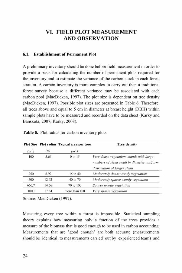
6. Plot radius for carbon inventory plots
24
v
LIST OF FIGURES 1. Land cover classification of MBNP and Permanent Sample
Plots distribution
11
2. The organizational structure of field measurement in Meru Betiri National Park
12
3. Structure of field measurement team
14
4. PSP design for measurement of carbon pools in Meru Betiri National Park
26
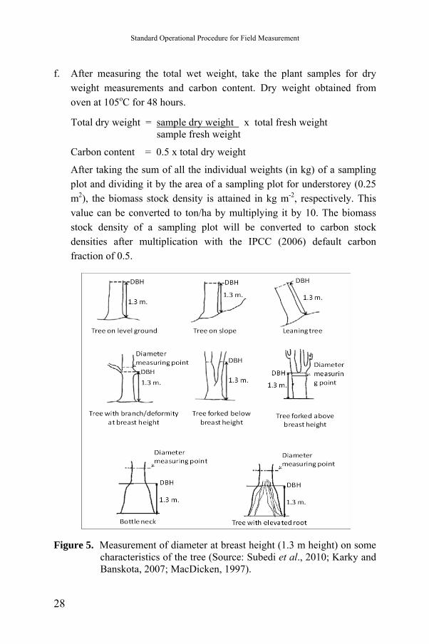
5. Measurement of diameter at breast height (1.3 m height) on some characteristics of the tree
28
6. Height measurements on several characteristics of the trees
29
7. Destructive sampling for under-storey
29
8. The placement of ring soil sampler on the soil surface
32
9. Position of ring soil sampler
33
10. Disposal of the remaining soil from the ring soil sampler
33
11. Placement of soil samples in plastic sample
34
vi
ABBREVIATIONS AND ACRONYMS
AGB : Above Ground Biomass
BGB : Below Ground Biomass
DBH : Diameter at Breast Height
DOM : Dry Organic Matter
EPA : Environmental Protection Agency
FAO : Food and Agricultural Organization
FORDA : Forest Research and Development Agency
GIS : Geographical Information Systems
GPS : Global Positioning System
IPCC GL : Intergovernmental Panel on Climate Change Guide Lines
JICA : Japan International Cooperation Agency
MBNP : Meru Betiri National Park
PSP : Permanent Sampling Plot
QA/QC : Quality Assurance/Quality Control
SOC : Soil Organic Carbon
SOPs : Standard Operating Procedures
REDD : Reducing Emission from Deforestation and Forest Degradation
USDA : United States Department of Agriculture
vii
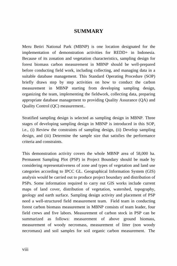
SUMMARY
Meru Betiri National Park (MBNP) is one location designated for the implementation of demonstration activities for REDD+ in Indonesia. Because of its zonation and vegetation characteristics, sampling design for forest biomass carbon measurement in MBNP should be well-prepared before conducting field work, including collecting, and managing data in a suitable database management. This Standard Operating Procedure (SOP) briefly draws step by step activities on how to conduct the carbon measurement in MBNP starting from developing sampling design, organizing the team, implementing the fieldwork, collecting data, preparing appropriate database management to providing Quality Assurance (QA) and Quality Control (QC) measurement.. Stratified sampling design is selected as sampling design in MBNP. Three stages of developing sampling design in MBNP is introduced in this SOP, i.e., (i) Review the constraints of sampling design, (ii) Develop sampling design, and (iii) Determine the sample size that satisfies the performance criteria and constraints. This demonstration activity covers the whole MBNP area of 58,000 ha. Permanent Sampling Plot (PSP) in Project Boundary should be made by considering representativeness of zone and types of vegetation and land use categories according to IPCC GL. Geographical Information System (GIS) analysis would be carried out to produce project boundary and distribution of PSPs. Some information required to carry out GIS works include current maps of land cover, distribution of vegetation, watershed, topography, geology and earth surface. Sampling design activity and placement of PSP need a well-structured field measurement team. Field team in conducting forest carbon biomass measurement in MBNP consists of team leader, four field crews and five labors. Measurement of carbon stock in PSP can be summarized as follows: measurement of above ground biomass, measurement of woody necromass, measurement of litter (non woody necromass) and soil samples for soil organic carbon measurement. The
viii

quality of any data stored must also be maintained by a continual process of correcting and updating activities. Thus data collection and database management takes an important role in forest carbon biomass measurement activity, especially if that is a repeating activity. Used of SOP is intended to get reliable and valid data to implement the Quality Assurance and Quality Control (QA/QC) during the forest carbon biomass measurement. Provisions for quality assurance (QA) and quality control (QC) must be implemented to ensure that the carbon stocks and credits reported are reliable and meet minimum measurement standards.
ix
RINGKASAN Taman Nasional Meru Betiri (TNMB) merupakan salah satu lokasi yang menjadi proyek percontohan kegiatan REDD di Indonesia. Karena karakteristik zonasi dan vegetasi, maka desain sampling untuk pengukuran karbon biomasa hutan di TNMB harus dipersiapkan sebelum melakukan pekerjaan lapangan, mengumpulkan data dan mengelola data dalam suatu manajemen database yang standar. Standar Operasional Prosedur (SOP) ini menjelaskan secara singkat tahap demi tahap bagaimana melakukan pengukuran karbon di TNMB yang dimulai dari pengembangan desain sampling, pengorganisasian tim, pelaksanaan di lapangan, pengumpulan data, penyusunan manajemen database yang sesuai, untuk penyediaan Jaminan Kualitas (QA) dan Kontrol Kualitas (QC) terhadap data yang dihasilkan. Desain sampling bertingkat dipilih sebagai desain sampling di TNMB. Tiga tahap pengembangan desain sampling di TNMB yang dijelaskan dalam SOP meliputi: 1) Review kendala desain sampling, 2) Pengembangan desain sampling, dan 3) Penentuan ukuran sampel sesuai yang memenuhi kriteria kinerja dan kendala. Kegiatan pengukuran biomasa karbon hutan mencakup seluruh wilayah TNMB seluas 58000 ha. Plot Sampling Permanen (PSP) dalam areal batas proyek kegiatan dilakukan dengan mempertimbangkan keterwakilan dari zonasi, tipe vegetasi dan kategori penggunaan lahan menurut Petunjuk IPCC. Sistem Informasi Geografis (SIG) dalam kegiatan ini menghasilkan areal batas proyek dan penentuan distribusi PSP. Beberapa informasi yang diperlukan untuk melaksanakan pekerjaan SIG meliputi peta-peta penutupan lahan, distribusi vegetasi, DAS, topografi, geologi dan permukaan bumi. Kegiatan desain sampling dan penempatan PSP membutuhkan tim pengukuran lapangan yang terstruktur secara baik. Tim Lapangan dalam melakukan pengukuran karbon biomasa hutan di TNMB terdiri dari pemimpin tim, empat kru lapangan dan lima tenaga kerja. Pengukuran stok karbon yang dilaksanakan dalam PSP meliputi: pengukuran biomasa
x
tegakan di atas tanah, pengukuran nekromas kayu, pengukuran serasah (bukan nekromas kayu) dan sampel tanah untuk pengukuran karbon organik tanah. Kualitas setiap data yang disimpan harus terjaga dalam suatu proses pengkoreksian dan updating data secara terus-menerus. Dengan demikian, kegiatan pengumpulan data dan manajemen database berperan penting dalam kegiatan pengukuran karbon biomasa hutan, terutama jika pengukuran tersebut merupakan aktivitas pengukuran yang berulang. Dalam rangka mendapatkan data yang handal dan valid, SOP ini merupakan salah satu untuk Jaminan Kualitas (QA ) dan Kontrol Kualitas (QC) selama pengukuran biomasa karbon hutan. Ketentuan jaminan kualitas (QA) dan kontrol kualitas (QC) harus dilaksanakan untuk memastikan bahwa data stok dan kredit karbon yang dilaporkan adalah handal dan telah memenuhi standar/syarat pengukuran minimum yang harus dilakukan.
xi

xii
Standard Operating Procedures (SOPs) for Field Measurement
I. INTRODUCTION A Standard Operating Procedure (SOP) refers to a set of written instructions of protocols or worksheet that document a routine or repetitive activity followed by an institution (EPA, 2007). SOPs can be seen as an integral part of a quality system as it provides information to do a series of job properly, and facilitates the consistency of quality and integrity of a product from the beginning to the end result. SOPs also document the way activities are to be undertaken in a consistent way to support data quality. The development and use of SOPs can minimize variation and promote quality through consistent implementation of a process or procedure within the organization, even if there are temporary or permanent personnel changes (EPA, 2007). When historical data are being evaluated for current use, SOPs can also be valuable for reconstructing a series of activities when no other references are available. Therefore, the benefits of a valid SOP are to reduce work effort, along with improved comparability, credibility, and legal defensibility. SOP is written for a standard analytical method and specifies the procedures to be followed in greater detail than appear in the published method. It also should detail how the SOP differs from at the standard method and any options that followed by the institutions. These differences are often caused by the slight changes or adjustments allowed by the general reference, but that can affect the final results. Using a correct well-written SOP can minimize such differences. The use of SOPs in the field measurement makes the job more effective and efficient. Team leader and field crew can synergize better in the field to achieve maximum result of field measurement. Clear SOPs provide the assurance of the workflow in the field so that it will not confuse the implementers in the field.
1
Standard Operational Procedure for Field Measurement
II. SAMPLING DESIGN 2.1. Definition and Purposes The sampling design is a fundamental part of data collection for scientifically based decision making. A well-developed sampling design plays a critical role to ensure the sufficient of data to formulate the conclusions. A complete sampling design indicates the number of samples and identifies the particular samples (for example, the geographic positions where these samples will be collected or the time points when samples will be collected). Along with this information, a complete sampling design will also explain and justify the number and the positions/timings of the samples. Main purpose of a sampling design in this project is to monitor and evaluate forest carbon biomass precisely based on its characteristics. A well-planned sampling design is intended to ensure that resulting data are adequately represents the target population. The efficient use of time, money, and human resources are critical considerations before selected the appropriate sampling design. A good sampling design should meet the needs of the study with a minimum expenditure of resources. 2.2. The Importance of Sampling Design The sampling design is necessary for data collection activities, especially if it conducted on a wide area and has varies characteristics. In order to find the appropriate data collection that can reflect the overall condition of the observed area, the location of sample design and data collection techniques should be selected appropriately and wisely. Forest biomass carbon measurements are research activities that require the support of accurate sampling design.
2
Standard Operating Procedures (SOPs) for Field Measurement
2.3. Type of Sampling Design Used This section briefly describes the stratified sampling design used in this project. The stratified sampling design is used due to the zonation of Meru Betiri National Park and type of vegetation there. In stratified sampling design, the target population is separated into non overlapping strata, or sub-populations that are known or thought to be more homogeneous, so that there tends to be less variation among sampling units in the same stratum than among sampling units in different strata. Strata may be chosen on the basis of spatial or temporal proximity of the units, or on the basis of preexisting information or professional judgment about the site or process. This design is useful for estimating a parameter when the target population is heterogeneous and the area can be subdivided based on expected contamination levels. Advantages of this sampling design are that it has potential for achieving greater precision in estimates of the mean and variance, and that it allows computation of reliable estimates for population subgroups of special interest. Greater precision can be obtained if the measurement of interest is strongly correlated with the variable used to make the strata. The precise step on how to develop the stratified sampling design is provided in Section 2.4 below. 2.4. Develop Sampling Design Sampling design in this project, i.e. stratified sampling design, is develop by using the following steps: a. Review the systematic planning outputs
1. State the sampling objectives
2. Specify the acceptance or performance criteria (such as probability limits on decision errors or estimation intervals).
3
Standard Operational Procedure for Field Measurement
3. Review the constraints regarding schedule, funding, special equipment and facilities, and human resources.
b. Develop sampling design
1. Decide whether the approach will involve episodic sampling events (where a sampling design is established and all data for that phase are collected according to that design) or an adaptive strategy (where a sampling protocol is established and sampling units are selected in the field, in accordance with the protocol, based on results from previous sampling for that phase).
2. Consider practical issues, schedule and budget risks, health and safety risks to project personnel and the community, and any other relevant issues of concern to those involved with the project.
c. Determine the sample size that satisfies the performance criteria
and constraints
1. Calculate the optimal sample size (and sample allocation, for stratified designs or other more complex designs).
2. Obtain agreement within the planning team on the appropriate design
2.5. Sampling Unit Selection and Distribution Total project area covers the whole MBNP of 58,000 ha. Permanent Sampling Plot (PSP) in Project Boundary is determined by considering representativeness of zone and types of vegetation and land use categories according to IPCC GL. According to the management plan, national park area is divided into several zones: nucleus, forest, intensive utilization, buffer (special utilization) and rehabilitation. Meanwhile basic forest types in MBNP consist of mangrove, coastal, swamp, tropical rainforest and bamboo forest.
4
Standard Operating Procedures (SOPs) for Field Measurement
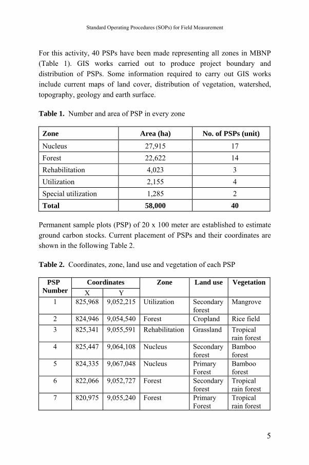
For this activity, 40 PSPs have been made representing all zones in MBNP (Table 1). GIS works carried out to produce project boundary and distribution of PSPs. Some information required to carry out GIS works include current maps of land cover, distribution of vegetation, watershed, topography, geology and earth surface. Table 1. Number and area of PSP in every zone Zone Area (ha) No. of PSPs (unit)
Nucleus 27,915 17 Forest 22,622 14 Rehabilitation 4,023 3 Utilization 2,155 4 Special utilization 1,285 2 Total 58,000 40
Permanent sample plots (PSP) of 20 x 100 meter are established to estimate ground carbon stocks. Current placement of PSPs and their coordinates are shown in the following Table 2.
Table 2. Coordinates, zone, land use and vegetation of each PSP
Coordinates PSP Number X Y
Zone Land use Vegetation
1 825,968 9,052,215 Utilization Secondary forest
Mangrove
2 824,946 9,054,540 Forest Cropland Rice field 3 825,341 9,055,591 Rehabilitation Grassland Tropical
rain forest 4 825,447 9,064,108 Nucleus Secondary
forest Bamboo forest
5 824,335 9,067,048 Nucleus Primary Forest
Bamboo forest
6 822,066 9,052,727 Forest Secondary forest
Tropical rain forest
7 820,975 9,055,240 Forest Primary Forest
Tropical rain forest
5
Standard Operational Procedure for Field Measurement
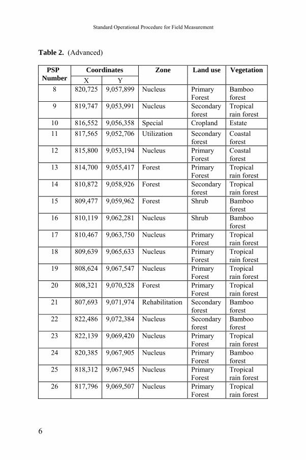
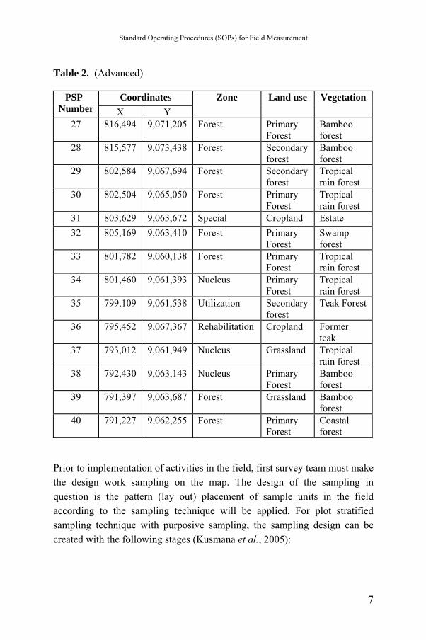
Table 2. (Advanced)
Coordinates PSP Number X Y
Zone Land use Vegetation
8 820,725 9,057,899 Nucleus Primary Forest
Bamboo forest
9 819,747 9,053,991 Nucleus Secondary forest
Tropical rain forest
10 816,552 9,056,358 Special Cropland Estate 11 817,565 9,052,706 Utilization Secondary
forest Coastal forest
12 815,800 9,053,194 Nucleus Primary Forest
Coastal forest
13 814,700 9,055,417 Forest Primary Forest
Tropical rain forest
14 810,872 9,058,926 Forest Secondary forest
Tropical rain forest
15 809,477 9,059,962 Forest Shrub Bamboo forest
16 810,119 9,062,281 Nucleus Shrub Bamboo forest
17 810,467 9,063,750 Nucleus Primary Forest
Tropical rain forest
18 809,639 9,065,633 Nucleus Primary Forest
Tropical rain forest
19 808,624 9,067,547 Nucleus Primary Forest
Tropical rain forest
20 808,321 9,070,528 Forest Primary Forest
Tropical rain forest
21 807,693 9,071,974 Rehabilitation Secondary forest
Bamboo forest
22 822,486 9,072,384 Nucleus Secondary forest
Bamboo forest
23 822,139 9,069,420 Nucleus Primary Forest
Tropical rain forest
24 820,385 9,067,905 Nucleus Primary Forest
Bamboo forest
25 818,312 9,067,945 Nucleus Primary Forest
Tropical rain forest
26 817,796 9,069,507 Nucleus Primary Forest
Tropical rain forest
6
Standard Operating Procedures (SOPs) for Field Measurement
Table 2. (Advanced)
Coordinates PSP Number X Y
Zone Land use Vegetation
27 816,494 9,071,205 Forest Primary Forest
Bamboo forest
28 815,577 9,073,438 Forest Secondary forest
Bamboo forest
29 802,584 9,067,694 Forest Secondary forest
Tropical rain forest
30 802,504 9,065,050 Forest Primary Forest
Tropical rain forest
31 803,629 9,063,672 Special Cropland Estate 32 805,169 9,063,410 Forest Primary
Forest Swamp forest
33 801,782 9,060,138 Forest Primary Forest
Tropical rain forest
34 801,460 9,061,393 Nucleus Primary Forest
Tropical rain forest
35 799,109 9,061,538 Utilization Secondary forest
Teak Forest
36 795,452 9,067,367 Rehabilitation Cropland Former teak
37 793,012 9,061,949 Nucleus Grassland Tropical rain forest
38 792,430 9,063,143 Nucleus Primary Forest
Bamboo forest
39 791,397 9,063,687 Forest Grassland Bamboo forest
40 791,227 9,062,255 Forest Primary Forest
Coastal forest
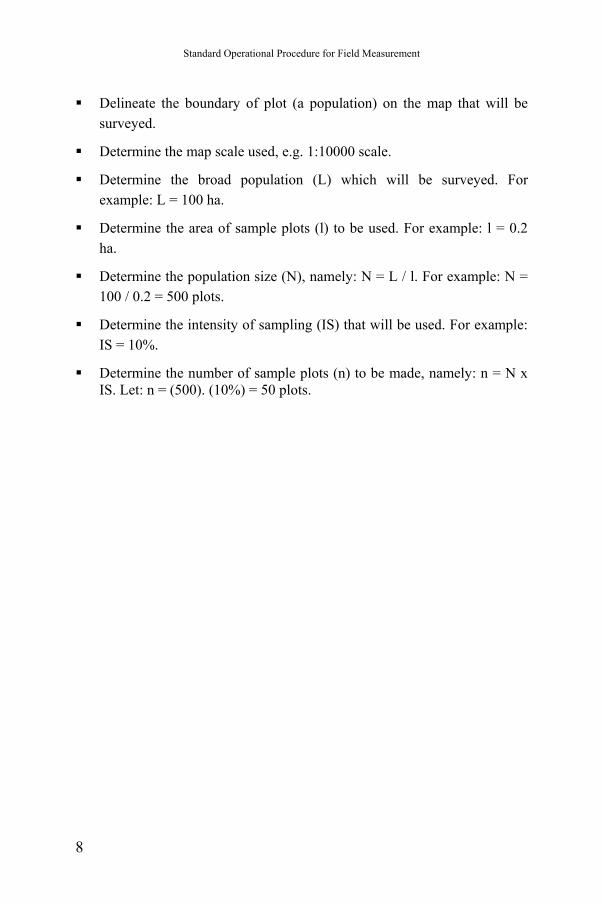
Prior to implementation of activities in the field, first survey team must make the design work sampling on the map. The design of the sampling in question is the pattern (lay out) placement of sample units in the field according to the sampling technique will be applied. For plot stratified sampling technique with purposive sampling, the sampling design can be created with the following stages (Kusmana et al., 2005):
7
Standard Operational Procedure for Field Measurement
Delineate the boundary of plot (a population) on the map that will be surveyed.
Determine the map scale used, e.g. 1:10000 scale.
Determine the broad population (L) which will be surveyed. For example: L = 100 ha.
Determine the area of sample plots (l) to be used. For example: l = 0.2 ha.
Determine the population size (N), namely: N = L / l. For example: N = 100 / 0.2 = 500 plots.
Determine the intensity of sampling (IS) that will be used. For example: IS = 10%.
Determine the number of sample plots (n) to be made, namely: n = N x IS. Let: n = (500). (10%) = 50 plots.
8
Standard Operating Procedures (SOPs) for Field Measurement
III. LAND COVER CLASSIFICATION 3.1. Definition and Classification of Land Cover Land cover and land use represent the integrating elements of the resource base. Land cover is the expression of human activities and its changes. Changes in land cover and land use affect the global systems (e.g., atmosphere, climate). Hence, land cover is a geographical feature which may form a reference base for many applications, e.g. forest and rangeland monitoring, statistics, planning, investment, biodiversity and climate change. Land use is characterized by the arrangements, activities and inputs people undertake in a certain land cover type to produce, change or maintain it. Definition of land use in this way establishes a direct link between land cover and the actions of people in their environment. Classification is an abstract representation of the situation in the field using well-defined diagnostic criteria known as the classifiers. Sokal (1974) defined it as: “the ordering or arrangement of objects into groups or sets on the basis of their relationships.” A classification describes the systematic framework with the names of the classes and the criteria used to distinguish them, and the relation between classes. Classification thus necessarily involves definition of class boundaries that should be clear, precise, possibly quantitative, and based upon objective criteria. Forestry activities and the land base for an entity can vary in size and can be confined to a single or several geographic areas. Indonesian forestry has 23 land cover classification that made by Directorate General of Forestry Planning (Table 3). The spatial boundaries of the land need to be clearly defined to facilitate accurate measuring, monitoring, accounting, and verification. The spatial boundaries can be in the form of permanent boundary markers, e.g., fences; clearly defined topographic descriptions, e.g., rivers/creeks, mountain ridges; spatially explicit boundaries (identified with a Global Positioning System, GPS); and/or other methods. Ground-based surveys that delineate property boundaries are an accurate means of
9
Standard Operational Procedure for Field Measurement
documenting land boundaries. Many methods and tools are available for identifying and delineating land boundaries, including remote sensing, e.g., satellite images from optical or radar sensor systems, aerial photos, GPS, topographic maps, and land records.
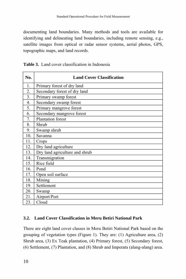
Table 3. Land cover classification in Indonesia
No. Land Cover Classification
1. Primary forest of dry land 2. Secondary forest of dry land 3. Primary swamp forest 4. Secondary swamp forest 5. Primary mangrove forest 6. Secondary mangrove forest 7. Plantation forest 8. Shrub 9. Swamp shrub
10. Savanna 11. Crops 12. Dry land agriculture 13. Dry land agriculture and shrub 14. Transmigration 15. Rice field 16. Pond 17. Open soil surface 18. Mining 19. Settlement 20. Swamp 21. Airport/Port 23. Cloud
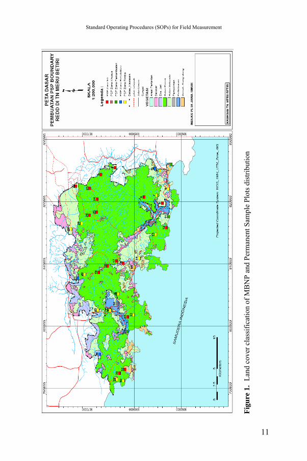
3.2. Land Cover Classification in Meru Betiri National Park There are eight land cover classes in Meru Betiri National Park based on the grouping of vegetation types (Figure 1). They are: (1) Agriculture area, (2) Shrub area, (3) Ex Teak plantation, (4) Primary forest, (5) Secondary forest, (6) Settlement, (7) Plantation, and (8) Shrub and Imperata (alang-alang) area.
10
Standard Operating Procedures (SOPs) for Field Measurement
Figu
re 1
. La
nd c
over
cla
ssifi
catio
n of
MB
NP
and
Perm
anen
t Sam
ple
Plot
s dis
tribu
tion
11
Standard Operational Procedure for Field Measurement
IV. ORGANISATIONAL STRUCTURE AND RESPONSIBILITIES
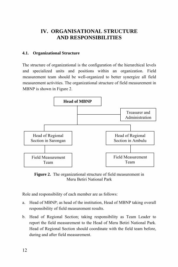
4.1. Organizational Structure The structure of organizational is the configuration of the hierarchical levels and specialized units and positions within an organization. Field measurement team should be well-organized to better synergize all field measurement activities. The organizational structure of field measurement in MBNP is shown in Figure 2. Head of MBNP Treasurer and
Administration Head of Regional
Section in Sarongan Head of Regional
Section in Ambulu Field Measurement
Team Field Measurement
Team
Figure 2. The organizational structure of field measurement in Meru Betiri National Park
Role and responsibility of each member are as follows:
a. Head of MBNP; as head of the institution, Head of MBNP taking overall responsibility of field measurement results.
b. Head of Regional Section; taking responsibility as Team Leader to report the field measurement to the Head of Meru Betiri National Park. Head of Regional Section should coordinate with the field team before, during and after field measurement.
12
Standard Operating Procedures (SOPs) for Field Measurement
c. Treasurer and Administration; taking responsibility in preparing budget, administration and report after the completion of field measurement. Treasurer and Administration responsible to Head of Meru Betiri National Park and should provide report of each activities being done to the Head of Regional Section.
d. Field Team; conducting field measurement in the forest. Field measurement team consists of staff/technical staff of MBNP and local community surrounding forest. Field Measurement Team responsible to Head of Regional Section.
4.2. Composition and Structure of Field Measurement Team Field measurement team consists of team leader, field crews and labors. Number of field team personnel (field crew/labor) depends to budget and time available. Number of personnel could be added if there is enough budget and time. Minimal number of field crew and labors needed for each PSP is shown in Table 4. Figure 3 showed the structure of field measurement team. Table 4. Minimal number of field measurement team personnel in each PSP No. Indicators Field Crew
(person) Labors
(person) 1. Above ground biomass: a. DBH (cm) of stand (saplings, poles
and trees) b. Height (m) of stand (saplings, poles
and trees)
1 1
c. Seedlings and shrubs 1 2 2. Litter 3. Soil
1 1
4. Necromass 1 1 Total 4 5
13
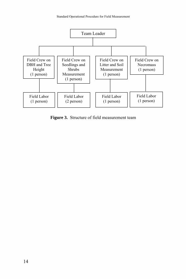
Standard Operational Procedure for Field Measurement
Team Leader
Field Crew on DBH and Tree
Height (1 person)
Field Crew on Seedlings and
Shrubs Measurement
(1 person)
Field Crew on Litter and Soil Measurement
(1 person)
Field Crew on Necromass (1 person)
Field Labor (1 person)
Field Labor (2 person)
Field Labor (1 person)
Field Labor (1 person)
Figure 3. Structure of field measurement team
14
Standard Operating Procedures (SOPs) for Field Measurement
V. FIELDWORK 5.1. Procedure The fieldwork should be carried out in a series of well programmed activities starting from planning, preparation, implementation, until the results achievement to gain the expected result. Among procedures needed before fieldwork implementation is field orientation. Fieldwork could be executed only after the team is properly oriented and ready to carry out measurement activities. Field orientation consists of permanent plot navigation, center plot marking and referencing, and slope correction. Field orientation should be done properly before the team carry out forest carbon measurement. In field orientation, firstly the team has to navigate to the place where the permanent plot has been established. As soon as the team reaches the plot, it needs to mark the center point and its referencing and correct the slope before collect data on the different carbon pools. 5.1.1. Permanent plot navigation Permanent plot navigation carried out after loading sample plot locations on to the GPS receiver. Sample plots are navigated to in the field by using a GPS receiver. 5.1.2. Center point marking and referencing Center points of all plots must be marked permanently in the field. The distances and bearing between the center and at least 3 or 4 permanent reference points should be recorded. Stones or trees could be used as permanent reference points. The references should be distributed around the center. The sketch of the plot center references, their distances, and bearings to the center must be recorded and shown on the inventory form. 5.1.3. Slope correction While placing a permanent sample plot, care must be taken to do a correction for any slopes in the area. A clinometer can be used to measure
15
Standard Operational Procedure for Field Measurement
slope angles. Tree distance and other distance measurement then should be corrected by considering this slope to obtain their horizontal distances. Table of slope correction is provided in Annex d. 5.1.4. Forest carbon stock measurement After slope correction, the major work of carbon measurement starts. Here, above-ground biomass; understorey; woody necromass; litter and soil organic carbon. 5.2. Overview of Data Collection Process Collecting data is a very important role in forest measurement activity, especially if that is a repeating activity. Data collection has to be good enough and no compromises can be made. For that all the crew members taking part in forest carbon measurement should understand the basic ideas behind forest carbon measurement and how to use all the materials and equipment to obtain appropriate result needed. Forest carbon measurement should be carried out with care to ensure the collection of complete data. Therefore before collected the data, the team should made proper preparation in order to obtain appropriate result and effectiveness of the work. The quality of data depends on the quality assurance level of the data collector. Field data is collected using field forms/tally sheet. All validated field data will then be entered into well-prepared data base computer. Database software such as MS-Access provides useful assistance to manage these field data into computerized database. Input data for database is taken from field data collected in tally sheet. This database then plays an important role to prepare and provide information and useful output for the users such as reports or graphs, and also for data analysis. Procedures for preparing the database management are briefly described in Section 8.
16
Standard Operating Procedures (SOPs) for Field Measurement
5.3. Preparation for the Fieldwork Preparation is a very important activity prior to field execution. Fatal error in field preparation could result in reliability of data recording. Some preparation activities prior to fieldwork among others are: 5.3.1. Preparation of the field forms Availability of various field forms is needed to ensure that every parameter in the field is collected appropriately. Examples of field forms/tally sheet for the measurements are provided in the Annex a, Annex b and Annex c. 5.3.2. Preparation of the field maps and GPS setup Field map should be prepared in proper way before conducting the fieldwork. A field map should include basic information of the plot, e.g. coordinates of the plot, forest type and densities, topography, land use, etc; those can be derived from a base map. The used of GPS is very helpful to locate and produce field map accurately. Locations of random sample plots could be derived from a base map. Plots are laid out or distributed randomly within each stratum using standard sampling methods or software. Coordinates of each plot are also generated and loaded into the GPS. Center of each plot is permanently fixed by using cemented or wooden pillars marked with permanent paint. The marking in the center of the plots is needed for annual monitoring as GPS alone could give a few meters of difference in locating the center of the permanent plot for subsequent measurement. Availability of high-resolution satellite images is more preferable in developing the base map. A base map specifies the details of the project area by indicating the different land-use categories (forest, water bodies, open land, agricultural land, etc). Different amounts of carbon stored will be found under different forest types, density, and species. GPS points are used for geo-referencing to increase accuracy and precision on satellite images and GIS data. Satellite images and global positioning
17
Standard Operational Procedure for Field Measurement
systems (GPS Map 60CSx, Garmin) are used for verification. GPS tracking is the most accurate and efficient alternative method for boundary delineation, even if the process is time consuming. Each forest block should be traced on to base maps first and then digitized on Arc View or ARC GIS software for data input. The data tracking from the GPS receiver is downloaded as a shape file, e.g., DNR Garmin software can be used. The areas of individual forest blocks are estimated after digitizing and editing the data downloaded. Below are procedures for setting up the GPS (GPS Map 60CSx, Garmin) before using it in the field: Initial set up
1. Go to the Main Menu page by pressing the Page Key (There are six pages: Satellite page, Trip composer, Map page, Compass, Altimeter and Main Menu).
2. Highlight Setup Menu and press Enter Key. When the set up page is displayed, highlight the System icon and press Enter again.
3. Set the following system set up using the Roger Key: GPS –Normal; WAAS/EGNOS – Disabled; Battery Type – Alkaline, Text Language – English; External Power Lost – Turn Off; Proximity Alarms – On.
4. Quit this page using the Quit Key. Unit set up
Setting up the unit is an important step and can be done as per the following instructions. In the Set-up Menu page, highlight the Units icon, and press Enter. Set the following Units Set up using the Roger Key.
1. Position Format – Users UPS (choose a coordinate system according to your working area).
18
Standard Operating Procedures (SOPs) for Field Measurement
2. Map Datum – WGS 84 (It is a description of the geographic location for surveying, mapping, and navigation).
3. Distance/Speed – Matrices.
4. Elevation (vert. Speed) – Meter.
5. Depth – Meter.
6. Temperature – Celsius/Fahrenheit.
7. Pressure – Millibars. Marking the current location
1. To quickly capture your current location, press and hold the Mark Key until the Mark Waypoint page appears.
2. At the top of the screen, a 3 digit Waypoint name appears as a default: highlight it and press the Enter key.
3. Use the Rocker to enter the name of the captured Waypoint and press OK on the keyboard (You can also edit the Waypoint and manually load new Waypoints using this page).
4. Press OK at the bottom right of the Mark Waypoint page and then press quit to exit.
5. To find the Waypoint press Find Key to open the Find Menu.
6. Highlight the Waypoints’ icon and press Enter.
7. Highlight any Waypoint and press Enter, information on the Waypoint selected is displayed.
Delineating the forest boundary
Tracks are used to depict line and polygon features.
1. To set up a track log press twice on the Menu key to open the Main Menu page.
2. Select the Tracks’ icon and press Enter to open the Track page.
3. Highlight the Set up button, and Press Enter to open the Track Log Set up page and set up the following : Record Method – Distance; Interval – 5m; Color – Transparent.
19
Standard Operational Procedure for Field Measurement
4. To survey CFUG boundaries select On in the Track Log and press Enter once: similarly, after tracking select Off in the Track Log and press Enter once.
5. To save the entire Track Log, open the Track page and activate the Save Button. A message asks if you want to save the entire track. Select Yes and press Enter to save the track.
6. Tips: You can rename the track in the same way used for saving Waypoints.
7. Press OK and exit from this page. 5.3.3. Field equipment per team Field equipment to be prepared should be suitable in conformity with the need of every parameter concerned. Gathering the equipments required before moving to the field is crucial. All instruments and pieces of equipment should be collected early enough so that they can be prepared, checked and calibrated in advance. The operational team has to ensure that every instrument is functioning, so that field work can take place without any disturbance. Table 5 indicates the field equipment and/or materials supposed to be important for different parameters concerned during the field work:
20
Standard Operating Procedures (SOPs) for Field Measurement
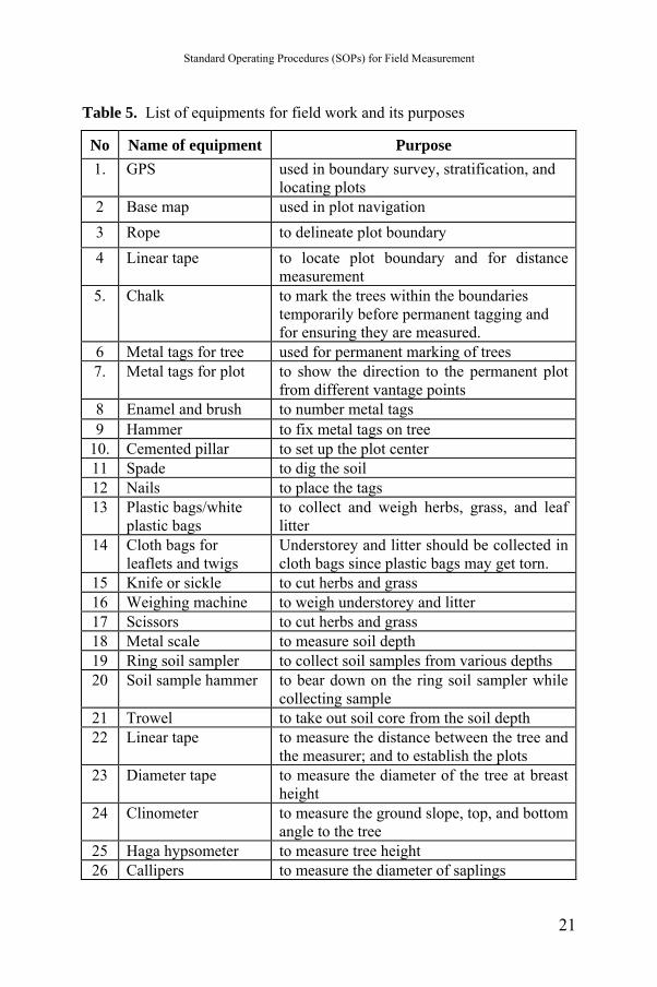
Table 5. List of equipments for field work and its purposes
No Name of equipment Purpose 1. GPS used in boundary survey, stratification, and
locating plots 2 Base map used in plot navigation 3 Rope to delineate plot boundary 4 Linear tape to locate plot boundary and for distance
measurement 5. Chalk to mark the trees within the boundaries
temporarily before permanent tagging and for ensuring they are measured.
6 Metal tags for tree used for permanent marking of trees 7. Metal tags for plot to show the direction to the permanent plot
from different vantage points 8 Enamel and brush to number metal tags 9 Hammer to fix metal tags on tree
10. Cemented pillar to set up the plot center 11 Spade to dig the soil 12 Nails to place the tags 13 Plastic bags/white
plastic bags to collect and weigh herbs, grass, and leaf litter
14 Cloth bags for leaflets and twigs
Understorey and litter should be collected in cloth bags since plastic bags may get torn.
15 Knife or sickle to cut herbs and grass 16 Weighing machine to weigh understorey and litter 17 Scissors to cut herbs and grass 18 Metal scale to measure soil depth 19 Ring soil sampler to collect soil samples from various depths 20 Soil sample hammer to bear down on the ring soil sampler while
collecting sample 21 Trowel to take out soil core from the soil depth 22 Linear tape to measure the distance between the tree and
the measurer; and to establish the plots 23 Diameter tape to measure the diameter of the tree at breast
height 24 Clinometer to measure the ground slope, top, and bottom
angle to the tree 25 Haga hypsometer to measure tree height 26 Callipers to measure the diameter of saplings
21
Standard Operational Procedure for Field Measurement
5.4. Introduction of the Project to the Local People Local people can be trained to carry out forest inventories employing the standard methods used in forestry and recommended by e.g. the IPCC Good Practice Guide (IPCC, 2003). If the carbon savings can be credited, this could act as an incentive the communities for carrying out management and conservation activities. Here sample will be taken for all above ground biomass (trees, shrubs and herb layers, and litter) but not take soil carbon measurements, both because of the technical difficulties of estimating changes in soil carbon over time, and because it is not yet clear whether soil carbon will generate carbon credits under REDD. Below ground biomass is calculated using a standard expansion factor. The reliability of the carbon estimates made by communities then will tested by hiring independent professional foresters to re-survey three of the sites used in the research 5.5. Field Data Collection After the team is properly oriented and ready to carry out measurement activities, it has to navigate to the place where the permanent plot has been established. As soon as the team reaches the plot, it needs to collect data about the different carbon pools. Among data should be collected from the plot are as follows: 1. Data cover sheet, including:
- permanent plot navigation data,
- center point marking and referencing,
- sketch of the plot layout, and
- slope correction.
22

Standard Operating Procedures (SOPs) for Field Measurement
2. Forest carbon stock measurement
Among parameters measured in this measurement are:
- above-ground biomass,
- understorey,
- woody necromass,
- litter, and
- soil organic carbon.
23
Standard Operational Procedure for Field Measurement
VI. FIELD PLOT MEASUREMENT AND OBSERVATION
6.1. Establishment of Permanent Plot A preliminary inventory should be done before field measurement in order to provide a basis for calculating the number of permanent plots required for the inventory and to estimate the variance of the carbon stock in each forest stratum. A carbon inventory is more complex to carry out than a traditional forest survey because a different variance may be associated with each carbon pool (MacDicken, 1997). The plot size is dependent on tree density (MacDicken, 1997). Possible plot sizes are presented in Table 6. Therefore, all trees above and equal to 5 cm in diameter at breast height (DBH) within sample plots have to be measured and recorded on the data sheet (Karky and Banskota, 2007; Karky, 2008). Table 6. Plot radius for carbon inventory plots P
lot Size Plot radius Typical area per tree Tree density
(m2 ) (m) (m2 )100 5.64 0 to 15 Very dense vegetation, stands with large
numbers of stems small in diameter, uniformdistribution of larger stems
250 8.92 15 to 40 Moderately dense woody vegetation500 12.62 40 to 70 Moderately sparse woody vegetation
666.7 14.56 70 to 100 Sparse woody vegetation1000 17.84 more than 100 Very sparse vegetation
Source: MacDicken (1997). Measuring every tree within a forest is impossible. Statistical sampling theory explains how measuring only a fraction of the trees provides a measure of the biomass that is good enough to be used in carbon accounting. Measurements that are ’good enough’ are both accurate (measurements should be identical to measurements carried out by experienced team) and
24
Standard Operating Procedures (SOPs) for Field Measurement
precise (confidence interval around the mean should be sufficiently small). One half of the width of the 95% confidence interval around the mean divided by the mean should be less than 10% within a stratum. If it is greater than that, more samples should be taken within that stratum, or the stratum should be split into two more homogeneous strata. Thus, one needs to know the standard deviation of the measurements to know how many samples one needs. Therefore one has to have carried out the measurements in order to know this standard deviation.
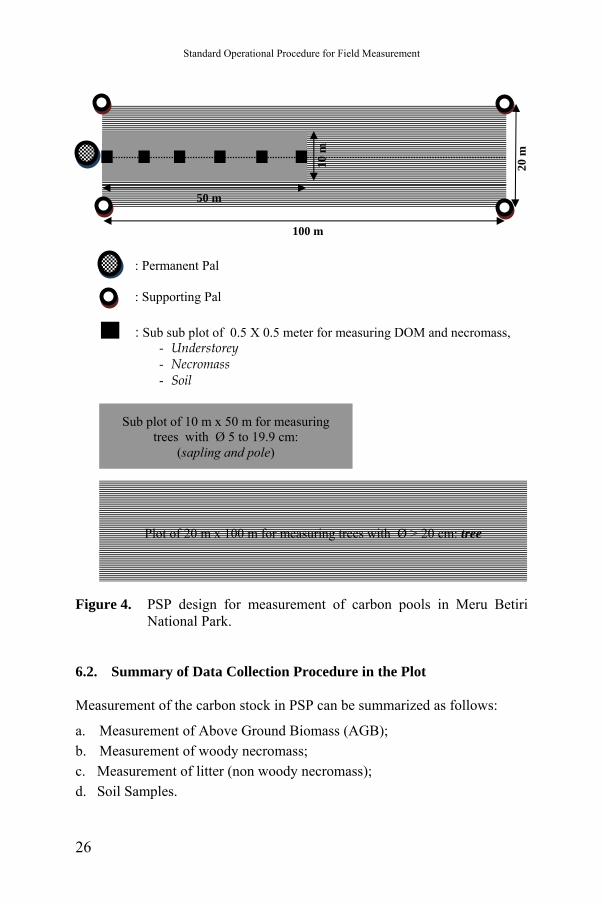
In these SOP, sample plots are established on a permanent basis to estimate changes in the forest carbon stock. Dividing the project area into relatively homogeneous strata could increase the accuracy and precision of carbon measurement and estimation. A stratified sampling design decreases the costs of monitoring because it diminishes the number of sampling plots required to acquire a set precision compared to a non-stratified sampling design. A stratified sampling design will allocate a greater number of plots in strata that have greater variability and, therefore, focus the sampling efforts in areas in which more accuracy is needed. Various design of sample plots have been applied for measurement of carbon stock in forestry project, including 40 x 30 m (JICA-Forda project), 100 x 100 (National Forest Inventory), 200 x 200 (PSP for monitoring of increment in mineral soil, Badan Litbang Kehutanan, 1993), 30 x 30 m (Dahlan et al., 2005), and 20 x 100 m (Asmoro, 2009; Hairiah and Rahayu, 2007; Hairiah et al., 2001a and b). Refers to ground based inventory, permanent sample plots (PSP) of 20 x 100 meter are established in MNBP to estimate its carbon stocks (Figure 4). The PSPs are used to estimate 5 carbon pools according to IPCC Guideline: above ground biomass (AGB), dead wood, litter and soil.
25
Standard Operational Procedure for Field Measurement
Figure 4. PSP design for measurement of carbon pools in Meru Betiri National Park.
6.2. Summary of Data Collection Procedure in the Plot Measurement of the carbon stock in PSP can be summarized as follows:
a. Measurement of Above Ground Biomass (AGB); b. Measurement of woody necromass; c. Measurement of litter (non woody necromass); d. Soil Samples.
Plot of 20 m x 100 m for measuring trees with Ø > 20 cm: tree
Sub plot of 10 m x 50 m for measuring trees with Ø 5 to 19.9 cm:
(sapling and pole)
: Sub sub plot of 0.5 X 0.5 meter for measuring DOM and necromass, - Understorey - Necromass - Soil
: Permanent Pal
: Supporting Pal
10 m
20 m
100 m
50 m
26
Standard Operating Procedures (SOPs) for Field Measurement
VII. DETAILS ON PLOT MEASUREMENTS
Plot measurement is the major work of carbon measurement. Here, above ground biomass, woody necromass, litter and soil sampling are measured in PSPs. 3.1. Above Ground Biomass (AGB) Measurement Above Ground Biomass is measured for living trees and understorey. AGB of living trees is measured with non-destructive method and applies allometric equation to obtain biomass. The allometric equation defined as statistical relationship between key characteristic dimension(s) of trees that are fairly easy to measure, such as DBH or height, and other properties that are more difficult to assess, such as above-ground biomass. The allometric equations are established in a empirical way on the basis of exact measurements from a relatively large sample of typical trees. In PSP measurement is carried out to record diameter of breast height, trees height and species of the trees. Measurement of diameter at breast height and tree height measurement is adjusted with trees characteristics. Figure 5 showed measurement of diameter at breast height on different characteristics of the tree. Measurement of tree height on some characteristics the trees is shown in Figure 6. Wood samples with certain diameter are taken to identify wood density. For under storey, destructive sampling carried out on sub-plots of 0.5 x 0.5 m. The following should be carried out for under storey destructive sampling activities: a. Determine the UC (Closure (%)) as the closure area by plant life/total
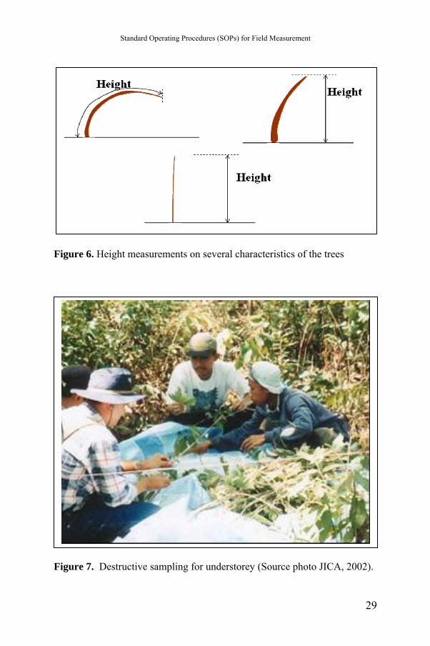
area (0.5 m x 0.5 m); b. Determine the UHmax (highest understorey height (m)); c. Create 10 sub plots within the plot for destructive sampling; d. Cut down all understorey (herbs and small seedlings) (Figure 7); e. Weigh the fresh weight of whole plant;
27
Standard Operational Procedure for Field Measurement
f. After measuring the total wet weight, take the plant samples for dry weight measurements and carbon content. Dry weight obtained from oven at 105oC for 48 hours.
Total dry weight = sample dry weight x total fresh weight sample fresh weight
Carbon content = 0.5 x total dry weight
After taking the sum of all the individual weights (in kg) of a sampling plot and dividing it by the area of a sampling plot for understorey (0.25 m2), the biomass stock density is attained in kg m-2, respectively. This value can be converted to ton/ha by multiplying it by 10. The biomass stock density of a sampling plot will be converted to carbon stock densities after multiplication with the IPCC (2006) default carbon fraction of 0.5.
Figure 5. Measurement of diameter at breast height (1.3 m height) on some
characteristics of the tree (Source: Subedi et al., 2010; Karky and Banskota, 2007; MacDicken, 1997).
28
Standard Operating Procedures (SOPs) for Field Measurement
Figure 6. Height measurements on several characteristics of the trees
Figure 7. Destructive sampling for understorey (Source photo JICA, 2002).
29
Standard Operational Procedure for Field Measurement
g. A total of 10 sub plots of 0.5 m x 0.5 m made to formulate allometric equation as follows:
WU = m(UC x UHmax)n Where: WU : total understorey biomass m, n : coefficients UC : closure of understorey (%) Uhmax : understorey height (the highest) (m)
7.2. Woody Necromass Measurement The dead organic matter pool (woody necromass) includes dead fallen trees, and other coarse woody debris above the soil surface. Within the plot, all woody debris and trunks (unburned part), dead standing trees, dead trees on the ground and stumps are sampled. Their height (length) and diameter are recorded, as well as notes identifying the type of wood for estimating specific density. The following should be carried out for woody necromass measurement:
a. Collect all of the standing stumps (DBH between 5 and 10 cm).
b. Collect all of the fallen stumps or wood with the base diameter between 10 and 15 cm.
c. Collect all of twigs or branches on the forest floor with the base diameter between 10 and 15 cm.
d. Calculate the volume of standing timber by measuring the DBH and length of standing timber.
e. Weigh the fallen timber, twigs and branches to determine the biomass and take samples for measurement of dry weight.
f. Dry weight obtained from oven at 105oC for 48 hours.
30
Standard Operating Procedures (SOPs) for Field Measurement
7.3. Litter (Non Woody Necromass) Measurement Litter consists of leaves and small branches above the ground as non woody necromass. Litter samples are collected from the same quadrants of 0.50 m x 0.50 m (0.25 m2) as used for under storey sample. Basically it is separated from coarse litter and fine litter. Coarse litter is any tree necromass less than 5 cm diameter and/or less than 50 cm length, undecomposed plant materials or crop residues, all unburned leaves and branches. Fine litter is at organic layer (0�5 cm above mineral soil layer) in the same quadrates, including all woody roots. The following should be carried out for litter measurement:
a. Place the frame size of 0.5 m x 0.5 m for the retrieval of litter.
b. Take all of the litter within the frame 0.5m x 0.5m until the ground floor in the frame is clean.
c. Dry weighted obtained from oven at 105oC for 48 hours. To minimize the contamination with mineral soil, the coarse litter samples should be soaked and washed in water; the floating litter is collected, sun dried and weighed, the rest is sieved on a 2 mm mesh sieve and added to the fine litter fraction. A subsample can be taken to obtain dry weight. 7.4. Soil Samples Soil organic carbon determined through samples collected from the default depth prescribed by the IPCC (2006). Soil samples are taken from three layers (depth), 0-10 cm, 10-20 cm dan 20-30 cm at six points on each plot. Soil samples are analyzed in the laboratory as composite samples to identify chemical properties such as pH and C content. Undisturbed soil samples are also taken for physical analysis, especially the 'bulk density', and (specific gravity) of the soil which is essential to convert the soil dry weights into soil volume. To estimate bulk density, soil sample is taken from three depths (0-10 cm, 10-20 cm, and 20-30 cm) by using standardized ring sampler.
31
Standard Operational Procedure for Field Measurement
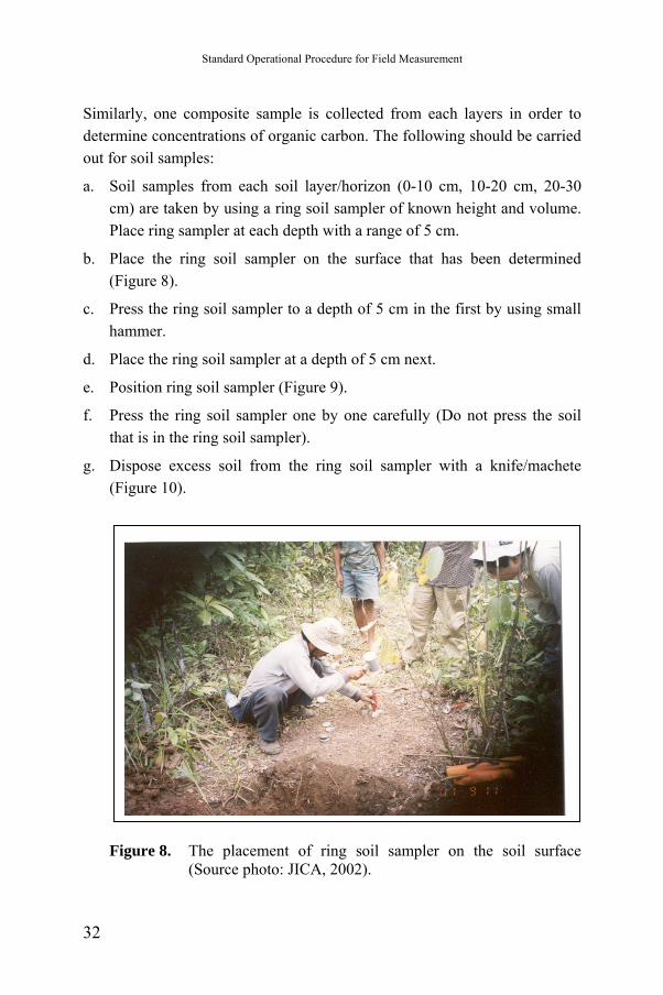
Similarly, one composite sample is collected from each layers in order to determine concentrations of organic carbon. The following should be carried out for soil samples:
a. Soil samples from each soil layer/horizon (0-10 cm, 10-20 cm, 20-30 cm) are taken by using a ring soil sampler of known height and volume. Place ring sampler at each depth with a range of 5 cm.
b. Place the ring soil sampler on the surface that has been determined (Figure 8).
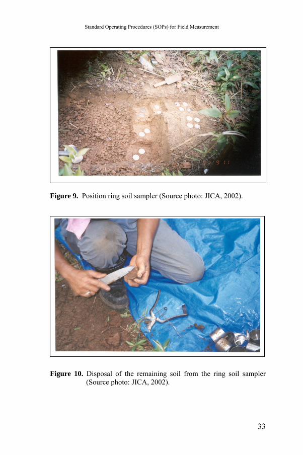
c. Press the ring soil sampler to a depth of 5 cm in the first by using small hammer.
d. Place the ring soil sampler at a depth of 5 cm next.
e. Position ring soil sampler (Figure 9).
f. Press the ring soil sampler one by one carefully (Do not press the soil that is in the ring soil sampler).
g. Dispose excess soil from the ring soil sampler with a knife/machete (Figure 10).
Figure 8. The placement of ring soil sampler on the soil surface (Source photo: JICA, 2002).
32
Standard Operating Procedures (SOPs) for Field Measurement
Figure 9. Position ring soil sampler (Source photo: JICA, 2002).
Figure 10. Disposal of the remaining soil from the ring soil sampler (Source photo: JICA, 2002).
33
Standard Operational Procedure for Field Measurement
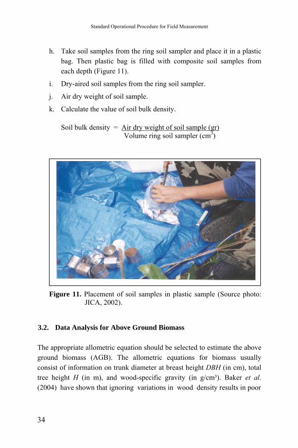
h. Take soil samples from the ring soil sampler and place it in a plastic bag. Then plastic bag is filled with composite soil samples from each depth (Figure 11).
i. Dry-aired soil samples from the ring soil sampler.
j. Air dry weight of soil sample.
k. Calculate the value of soil bulk density. Soil bulk density = Air dry weight of soil sample (gr)
Volume ring soil sampler (cm3)
Figure 11. Placement of soil samples in plastic sample (Source photo: JICA, 2002).
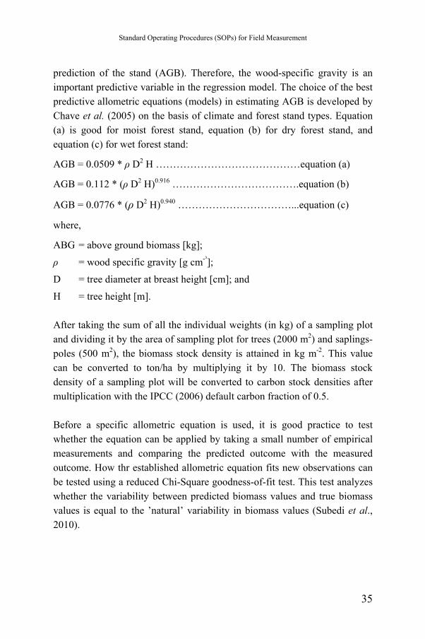
3.2. Data Analysis for Above Ground Biomass The appropriate allometric equation should be selected to estimate the above ground biomass (AGB). The allometric equations for biomass usually consist of information on trunk diameter at breast height DBH (in cm), total tree height H (in m), and wood-specific gravity (in g/cm³). Baker et al. (2004) have shown that ignoring variations in wood density results in poor
34
Standard Operating Procedures (SOPs) for Field Measurement
prediction of the stand (AGB). Therefore, the wood-specific gravity is an important predictive variable in the regression model. The choice of the best predictive allometric equations (models) in estimating AGB is developed by Chave et al. (2005) on the basis of climate and forest stand types. Equation (a) is good for moist forest stand, equation (b) for dry forest stand, and equation (c) for wet forest stand:
AGB = 0.0509 * ρ D2 H ……………………………………equation (a)
AGB = 0.112 * (ρ D2 H)0.916 ……………………………….equation (b)
AGB = 0.0776 * (ρ D2 H)0.940 ……………………………...equation (c)
where,
ABG = above ground biomass [kg];
ρ = wood specific gravity [g cm-³];
D = tree diameter at breast height [cm]; and
H = tree height [m]. After taking the sum of all the individual weights (in kg) of a sampling plot and dividing it by the area of sampling plot for trees (2000 m2) and saplings-poles (500 m2), the biomass stock density is attained in kg m-2. This value can be converted to ton/ha by multiplying it by 10. The biomass stock density of a sampling plot will be converted to carbon stock densities after multiplication with the IPCC (2006) default carbon fraction of 0.5. Before a specific allometric equation is used, it is good practice to test whether the equation can be applied by taking a small number of empirical measurements and comparing the predicted outcome with the measured outcome. How thr established allometric equation fits new observations can be tested using a reduced Chi-Square goodness-of-fit test. This test analyzes whether the variability between predicted biomass values and true biomass values is equal to the ’natural’ variability in biomass values (Subedi et al., 2010).
35
Standard Operational Procedure for Field Measurement
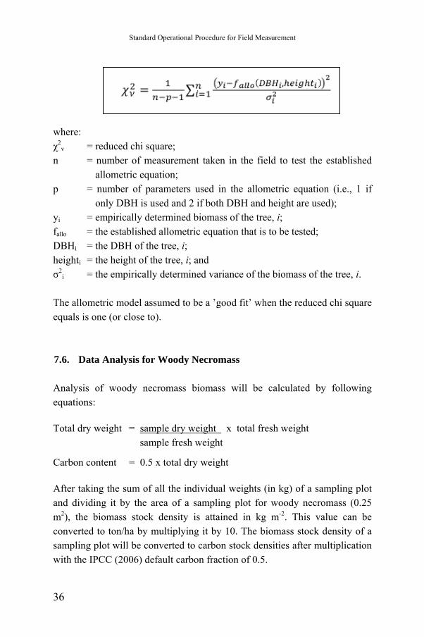
where: χ2
v = reduced chi square;
n = number of measurement taken in the field to test the established allometric equation;
p = number of parameters used in the allometric equation (i.e., 1 if only DBH is used and 2 if both DBH and height are used);
yi = empirically determined biomass of the tree, i; fallo = the established allometric equation that is to be tested; DBHi = the DBH of the tree, i; heighti = the height of the tree, i; and σ2
i = the empirically determined variance of the biomass of the tree, i. The allometric model assumed to be a ’good fit’ when the reduced chi square equals is one (or close to). 7.6. Data Analysis for Woody Necromass Analysis of woody necromass biomass will be calculated by following equations: Total dry weight = sample dry weight x total fresh weight
sample fresh weight
Carbon content = 0.5 x total dry weight After taking the sum of all the individual weights (in kg) of a sampling plot and dividing it by the area of a sampling plot for woody necromass (0.25 m2), the biomass stock density is attained in kg m-2. This value can be converted to ton/ha by multiplying it by 10. The biomass stock density of a sampling plot will be converted to carbon stock densities after multiplication with the IPCC (2006) default carbon fraction of 0.5.
36
Standard Operating Procedures (SOPs) for Field Measurement
7.7. Data Analysis for Litter To determine the litter biomass, samples are taken destructively in the field within a small area of 0.25 m2. Fresh samples are weighed in the field with a 0.1 gr precision; and a well-mixed sub-sample is then placed in a marked bag. A sample is taken to the laboratory and oven dried until constant weight to determine water content. For the amount of biomass per unit area is given by:
WL = W field fresh x W dry sample x 1. P W wet sample 10000
where: WL = biomass of litter (t ha-1); W field fresh = weight of the fresh field sample of litter, destructively
sampled within an area of size P [g]; P = size of the area in which litter were collected [ha]; W dry sample = weight of the oven-dry sample of litter taken to the
laboratory to determine moisture content [g]; and W wet sample = weight of the fresh sample of litter taken to the
laboratory to determine moisture content [g]. 7.8. Data Analysis for Soil Organic Carbon Soil samples from each of the three depths are composted and well-mixed per sampling plot and then prepared for carbon measurement by removing stones and plant residue > 2mm as well as by grinding. The carbon stock density of soil organic carbon is calculated as (Pearson et al., 2007): SOC = ρ x dp x %C Where: SOC = Soil organic carbon stock per unit area (t ha-1); ρ = soil bulk density [g cm-3]; dp = the total depth at which the sample was taken [cm]; and %C = carbon concentration [%].
37
Standard Operational Procedure for Field Measurement
7.9. Data Analysis for Total Carbon Stock Density Carbon stock density is calculated by using the following formula (Subedi et al., 2010). It should be noted that any individual carbon pool of the given formula can be ignored if it does not contribute significantly to the total carbon stock. C(LU) = C(AGTB)+C(AGPB)+C(AGSB)+C(AGUB)+C(L)+C(WN)+SOC where,
C(LU) = carbon stock density for a land-use category [ton ha-1];
C(AGTB) = carbon in above ground tree biomass [ton ha-1];
C(AGPB) = carbon in above ground pole biomass [ton ha-1];
C(AGSB) = carbon in above ground sapling biomass [ton ha-1];
C(AGUB) = carbon in above ground understorey biomass [ton ha-1];
C(L) = carbon in litter [ton ha-1];
C(WN) = carbon in woody necromass [ton ha-1];
SOC = soil organic carbon [ton ha-1]. The total carbon stock is then converted to tons of CO2 equivalent by multiplying it by 44/12, or 3.67 (Pearson et al., 2007).
38
Standard Operating Procedures (SOPs) for Field Measurement
VIII. DATABASE MANAGEMENT
8.1. The Importance of Database Management Data is commonly defined as fact findings or observations, typically about physical, biological phenomena or business transactions. More specifically, data are results of observations of the attributes (the characteristics) of entities (such as people, place, things and events). These measurements are usually represented by symbols such as numbers and words, or by code composed of a combination between numerical, alphabetical, and other characters (Deans and Kane, 1992). Collecting data and database management is a very important role in forest mensuration activity, especially if that is a repeating activity. The quality of any data stored must also be maintained by a continual process of correcting and updating activities. Data management can be defined as a system to manage data from raw data until the information for end users. So that, process and storage of data take an important role in data management. Storage is basic system component of data management system. Storage is the data management system activity in which data and information resources are retained in an organized manner for later use. Stored data is commonly organized into fields, records, files and databases (Deans and Kane, 1992).
8.2. Developing the Database Management Database management system plays an important role to prepare and provide information for the users, and also for data analysis. Database program, e.g. MS-Access could be used to develop the carbon database. Input data for the database is taken from field data. Then the selected program used will process the data into a useful output, such as reports or graphs. The database program uses referential integrity among its tables and uses query language
39
Standard Operational Procedure for Field Measurement
to process raw data that have been capturing in field data sheet. These referential integrity and query language will provide the users much more advantages to use this program, so that by following the instructions in this program, any user could operate this program easily. By using this program, any user could get any important information easily, such as trees growth or crown index, as well as to entry new data from filed data sheet / tally sheet. Following activities should be done in developing the database management system for carbon measurement:
1. Determine the availability of field data as input;
2. Determine the expected output;
3. Determine how to process those kind of input to the expected output, including preparing the appropriate equation;
4. Create the appropriate tables. Good tables should indicate specific characteristics of different dataset;
5. Carefully identify one parameter measured at each table as reference key in that table, e.g. trees number or plot number;
6. Create the referential integrity among tables;
7. Use the query language to process the raw data to get the expected output;
8. Create various kind of form, output or graph to provide various report on carbon biomass measurement.
40
Standard Operating Procedures (SOPs) for Field Measurement
IX. QUALITY ASSURANCE AND QUALITY CONTROL (QA/QC)
Provisions for quality assurance (QA) and quality control (QC) must be implemented to ensure that the reliability of carbon stocks and credits reported and that they meet minimum measurement standards. The QA/QC provisions are an integral part of standard operation procedures and include procedures for (Subedi et al., 2010; Pearson et al., 2007): (1) collecting reliable field measurements; (2) verifying laboratory procedures; (3) verifying data entry and analysis techniques; and (4) maintaining and archiving data. 9.1. Field Measurement Development of rigorous standard operating procedures (guidelines) is must to detail all steps taken in the field. Guidelines ensure the consistency and comparability of measurements that executed by different teams or at different times. Those responsible for carbon measurement must be trained extensively according to the guidelines. A document should be produced during every field visit proving that all steps from the guidelines have been followed: similarly. Any deviations from the guidelines must be listed in the field visit document. Updating of the guidelines should be done officially if significant issues arise with the procedures. Extensive training should be received by all field crews. An audit program for field measurements and sampling should be established with three types of checks: hot, cold and blind checks. During a hot check, auditors observe members of the field crew during data collection on a field plot, primarily for training purposes and correction of errors in techniques is allowed. Cold checks occur when field crews are not present for the audit. Blind checks represent the complete remeasurement of a plot by the auditors. Measurement variance can be calculated through blind checks. About 10% of the plots should be checked independently when fieldwork is completed.
41
Standard Operational Procedure for Field Measurement
Field data collected at this stage can be compared with the original data, and errors should be corrected and recorded. 9.2. Laboratory Measurement The SOPs also should be prepared by the operating entity and followed for each part of the analyses. Typical steps for the SOP for laboratory measurements include calibrating combustion instruments for measuring total carbon or carbon forms using commercially available certified carbon standards. All balances for measuring dry weights should be calibrated periodically. To estimate an error estimate, 10 - 20% of the samples should be reanalyzed/reweighed. A record of the procedure(s) should be obtained if a laboratory performs these steps. 9.3. Data Entry Laptop computers could be used to entry the data immediately in the field. However, in most cases measurements are entered manually on to spreadsheets and/or datasheets, that often a significant source of error. Attention must be paid to units used in the field. All measurement unit should clearly indicated in spreadsheets and/or datasheets. Spot checks of the data entered by independent personnel could reduce the errors can be reduced by. Outliers can be identified by checking whether each value is within an expected range. If during spot checks or range checks a significant number of errors found, all data should be re-checked by independent personnel. Then the plot should not be used in the analysis if there are anomalies that cannot be resolved. 9.4. Data Archiving Data archiving (maintenance and storage) is important due to the relatively long-term nature of forestry activities. Data archiving includes the following
42
Standard Operating Procedures (SOPs) for Field Measurement
steps: field measurement and laboratory data should be maintained in original form, placed on electronic media, and stored in a secure location. Copies of all data analyses, models, GIS products, and copy of reports should store in a secure location, preferably offsite.
43
Standard Operational Procedure for Field Measurement
REFERENCES Asmoro, J.P.P. 2009. Quantification of Carbon Sequestration on Production,
Conservation and Protected Forest. Manokwari Forestry Research Unit– Ministry of Forestry.
Badan Litbang Kehutanan. 1993. Manual of Establishment and Measurement PUP for Monitoring Forest Growth and Increament in Natural Dryland Forest after Logging. Badan Litbang Kehutanan. Jakarta.
Baker, T.R; Philips, O.L; Malhi, Y; Almeida, S; Arroyo, L; Di Fiore, A. 2004. Variation in wood density determines spatial patterns in Amazonian forest biomass. Global Change Biology 10 , 545-562.
Chave, J; Andalo, C; Brown, S; Cairns, M.A; Chambers, J.Q; Eamus, D. 2005. Tree allometry and improved estimation of carbon stocks. Oecologia, 87-99.
Cressie, N.A. 1993. Statistics for Spatial Data. John Wiley & Sons, New York.
Dahlan, I.N. Surati Jaya and Istomo. 2005. Estimated Carbon Stand mangium Willd Using Landsat ETM + and SPOT-5: Case Study on BKPH Parung Panjang, KPH Bogor MAPIN XIV Annual Scientific Meeting "Effective Utilization of Remote Sensing for Improving the Welfare of the Nation" . Rectorat Building 3rd floor, Campus Institut Teknologi Sepuluh Nopember Surabaya, 14 – 15 September 2005.
Darwin, R., Tsigas, M., Lewandrowski, J., & Raneses, A. 1996. Land use and cover in ecological economics. Ecological Economics, 17: 157-181.
Deans, P.C. & Kane, M.J. 1992. International dimensions of information systems and technology. Boston: PWS-Kent Publishing Company.
FAO. 1988. FAO-UNESCO Soil Map of the World. Revised Legend. FAO/UNESCO/ISRIC World Soil Resources Reports No. 60 (Reprinted 1990).
44
Standard Operating Procedures (SOPs) for Field Measurement
FAO. 2008. National Forest Monitoring and Assessment – Manual for integrated field data collection. National Forest Monitoring and Assessment Working Paper NFMA 37/E. Rome.
Hairiah, K. and Rahayu S. 2007. Measurement of Carbon Stock in Several Land Use. World Agroforestry Centre - ICRAF, SEA Regional Office, University of Brawijaya, Unibraw, Indonesia. 77 p.
Hairiah, K., Sitompul, S.M, van Noordwijk, M. and Palm, C.A., 2001 (a). Carbon stocks of tropical land use systems as part of the global C balance: effects of forest conversion and options for ‘clean development’ activities. ASB_LN 4A. In: Van Noordwijk, M, Williams, S.E. and Verbist, B. (Eds.) 2001.Towards integrated natural resource management in forest margins of the humid tropics: local action and global concerns. ASB-Lecture Notes 1 – 12. International Centre for Research in Agroforestry (ICRAF), Bogor, Indonesia.
_____________________________________________________., 2001 (b). Methods for sampling carbon stocks above and below ground. ASB_LN 4B. In: Van Noordwijk, M, Williams, S.E. and Verbist, B. (Eds.) 2001.Towards integrated natural resource management in -forest margins of the humid tropics: local action and global concerns. ASB-Lecture Notes 1 – 12. International Centre for Research in Agroforestry (ICRAF), Bogor, Indonesia.
IPCC. 2003. Good practice guidance for landuse, landuse change and forestry. Kanagawa, Japan: Institute for Global Environment Strategies.
_____. 2006. Good practice guidelines for National Greenhouse gas inventories. Switzerland: Intergovernmental panel on climate change.
Japan International Cooperation Agency/JICA. 2002. Demonstration Study on Carbon Fixing Forest Management Project. Progress report of the project 2001-2002.
Karky, B.S. 2008. The Economics of Reducing Emissions from Community Managed Forests in Nepal Himalaya. Dissertation submitted to obtain the degree of doctor at the University of Twente, Centre for Clean
45
Standard Operational Procedure for Field Measurement
Technology and Environmental Policy, Capitool 15 7000 AE Enschede, The Netherlands.
________; Banskota, K. 2007. Case study of a community-managed forest in Lamatar, Nepal. In K. Banskota, B. S. Karky, & M. Skutsch, Reducing Carbon Emissions through Community-managed Forests in the Himalaya (pp. 67 - 79). Kathmandu, Nepal: ICIMOD.
Kuechler, A.W., & Zonneveld, I.S. (eds.) 1988. Vegetation Mapping. Handbook of Vegetation Science, Vol. 10. Dordecht, the Netherlands: Kluwer Academic.
Kusmana, C., S. Wilarso, I. Hilwan, P. Pamoengkas, C. Wibowo, T. Tiryana, A. Triswanto, Yunasfi dan Hamzah. 2005. Teknik Rehabilitasi Mangrove. Fakultas Kehutanan. Institut Pertanian Bogor.
MacDicken, K.G. 1997. A Guide to Monitoring Carbon Storage in Forestry and Agro-forestry Projects. Arlington, USA: Winrock International.
Meyer, W.B., & Turner II, B.L. 1992. Human Population Growth and Global Land Use/Land Cover Change. pp. 39-61, in: Ann. Rev. Ecol. Syst., No. 23.
Myers, J.C. 1997. Geostatistical Error Management: Quantifying Uncertainty for Environmental Sampling and Mapping. Van Nostrand Reinhold, New York.
Pearson, Timothy R.H.; Brown, Sandra L.; Birdsey, Richard A. 2007. Measurement guidelines for the sequestration of forest carbon. Gen. Tech. Rep. NRS-18. Newtown Square, PA: U.S. Department of Agriculture, Forest Service, Northern Research Station. 42 p.
Sokal, R.R., Rohlf, F.J. 1995. Biometry: the principles and practice of statistics in biological research. 3rd ed. New York: W. H. Freeman and Co.
Subedi, B.P., S.S Pandey, A. Pandey., E.B. Rana., S. Bhattarai., T.R. Banskota., S. Charmakar., R. Tamrakar. 2010. Forest Carbon Stock Measurement: Guidelines for measuring carbon stocks in community-managed forests. Cooperation between: Asia Network for Sustainable Agriculture and Bioresources (ANSAB) - Federation of Community
46
Standard Operating Procedures (SOPs) for Field Measurement
Forest Users, Nepal (FECOFUN) - International Centre for Integrated Mountain Development (ICIMOD) - Norwegian Agency for Development Cooperation (NORAD).
Tamkrakar, P.R.(2000) Biomass and Volume Tables with Species Description for Community Forest Managment. Kathmandu: MoFSC, NARMSAP-TISC.
United States Office of Environmental Protection Information EPA. 2007. Guidance for Preparing Standard Operating Procedures (SOPs) EPA QA/G-6. Agency Washington, DC 20460 April 2007.
U.S. Environmental Protection Agency. 1998b. Guidance for Quality Assurance Project Plans (QA/G-5). EPA/600/R-98/018. Office of Research and Development, Washington, DC.
U.S. Soil Conservation Service. 1975. Soil Taxonomy, by the Soil Survey Staff. USDA Agriculture Handbook No. 436. Washington, D.C.
USDA Forest Service. 1999. Forest Health Monitoring 1999 Field Methods Guide. USDA Forest Service, National Forest Health Monitoring Program, Research Triangle Park, NC 27709.
47
Standard Operational Procedure for Field Measurement
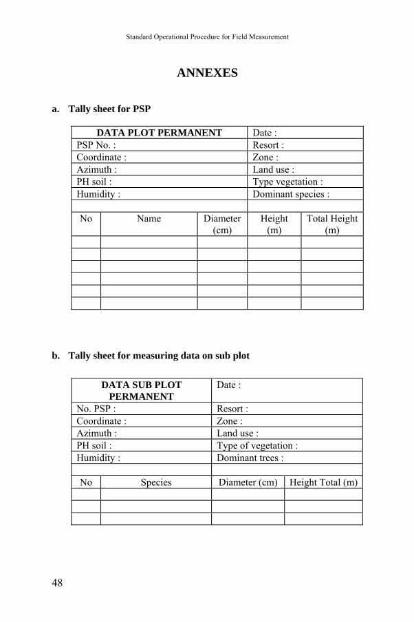
ANNEXES a. Tally sheet for PSP
DATA PLOT PERMANENT Date :
PSP No. : Resort : Coordinate : Zone : Azimuth : Land use : PH soil : Type vegetation : Humidity : Dominant species : No Name Diameter
(cm) Height
(m) Total Height
(m)
b. Tally sheet for measuring data on sub plot
DATA SUB PLOT
PERMANENT Date :
No. PSP : Resort : Coordinate : Zone : Azimuth : Land use : PH soil : Type of vegetation : Humidity : Dominant trees : No Species Diameter (cm) Height Total (m)
48
Standard Operating Procedures (SOPs) for Field Measurement
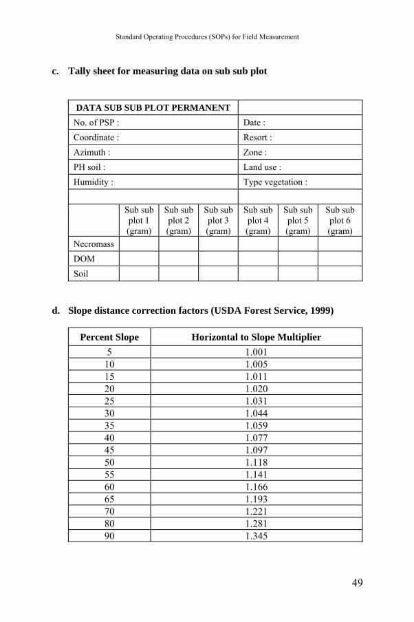
c. Tally sheet for measuring data on sub sub plot
DATA SUB SUB PLOT PERMANENT
No. of PSP : Date : Coordinate : Resort : Azimuth : Zone : PH soil : Land use : Humidity : Type vegetation :
Sub sub
plot 1 (gram)
Sub sub plot 2 (gram)
Sub sub plot 3 (gram)
Sub sub plot 4 (gram)
Sub sub plot 5 (gram)
Sub sub plot 6 (gram)
Necromass DOM Soil
d. Slope distance correction factors (USDA Forest Service, 1999)
Percent Slope Horizontal to Slope Multiplier
5 1.001 10 1.005 15 1.011 20 1.020 25 1.031 30 1.044 35 1.059 40 1.077 45 1.097 50 1.118 55 1.141 60 1.166 65 1.193 70 1.221 80 1.281 90 1.345
49

Standard Operational Procedure for Field Measurement
50
Related Documents